
Primeras pruebas del uso de vehículos aéreos no tripulados (VANTs) como herramienta de evaluación de impacto de castores en Tierra del Fuego (República Argentina)
DOI:
https://doi.org/10.31687/saremNMS.20.0.31Abstract
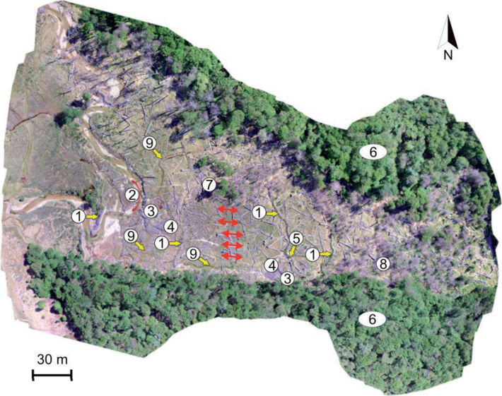
Different methods were used to evaluate beaver Castor canadensis, Khul 1820 populations, and their impact on the environment. The objective of this work was to evaluate the potential use of cenital aerial photographs taken with unmanned aerial vehicles (UAVs) as a new application tool for these activities, based on the generation, interpretation and application of the obtained information. The images obtained during the first tests allowed us to generate geo-referenced orthophotomosaics, digital elevation models (DEM), and topographic maps of high spatial resolution to detect different signs of beaver activity, of great use for the management of the species while reducing the time spent covering areas of difficult access.
References
Coronato, A., J. Escobar, C. Mallea, C. Roig, & M. Lizarralde. 2003. Características geomorfológicas de ríos de montaña colonizados por Castor canadensis en Tierra del Fuego, Argentina. Ecología Austral 13:15–26.
Deferrari, G. 2009. «Castores a la vista». Revista Dicho y Hecho 12:12.
Fesenmyer, K., D. C. Dauwalter, C. Evans, & T. Allai. 2018. Livestock management, beaver, and climate influences on riparian vegetation in a semi-arid landscape. PLoS ONE 13:e0208928.
Lizarralde, M. 1993. Current status of the beaver (Castor canadensis) introduced in Tierra del Fuego (Argentina). AMBIO 22:351–358.
Lizarralde, M., J. Escobar, & G. Deferrari. 2004. Invader species of Argentina: A review about beaver (Castor canadensis) population situation on Tierra del Fuego ecosystem. Interciencia 27:352–356.
Lizarralde, M., J. Escobar, G. Deferrari, & M. Fasanella. 2008. El castor (Castor canadensis) austral: Una especie invasora en el Archipiélago de Tierra del Fuego, Argentina. Investigación y Ciencia 379:58–64.
Lucieer, A., S. M. D. Jong, & D. Turner. 2014. Mapping landslide displacements using Structure from Motion (SfM) and image correlation of multi-temporal UAV photography. Progress in Physical Geography 38:97–116.
Maringer, A., & L. Slotta-Bachmayr. 2006. A GIS-based habitat-suitability model as a tool for the management of beavers Castor fiber. Acta Theriologica 51:373–382.
Mandujano, S., M. C. Mulero Pazmany, & A. Rísquez-Valdepeña. 2017. Drones: una nueva tecnología para el estudio y monitoreo de fauna y hábitats. Agroproductividad 10:79–84.
Snavely, N., S. M. Seitz, & R. Szeliski. 2008. Modeling the world from Internet photo collections. International Journal of Computer Vision 80:189–210.
Downloads
Published
How to Cite
Issue
Section
License
Copyright (c) 2020 Guillermo A. Deferrari, Julio M. Escobar, Juan F. Ponce, Diego Quiroga

This work is licensed under a Creative Commons Attribution-NonCommercial 4.0 International License.
